Arunachal Pradesh District Map (Source:- Survey of India)
About Arunachal Pradesh:-
Arunachal Pradesh is state located in North-Eastern Part of India and also the part of “Seven Sisters” State. Arunachal Pradesh was formed on 20 February, 1987. Arunachal Pradesh has the Area of 83,743 sq. km with 22 Districts. Arunachal Pradesh has the population of 13,83,727 person with Urban Population of 3,17,427 and Rural Population of 10,66,300. The State has Male Population of 7,13,912 and Female Population of 6,69,815 with the Sex Ratio of 938 Female Per 1000 Male. Arunachal Pradesh has the Density of 17 Per Sq. km. and the Literacy Rate of 65.38% (DATA ACCORDING TO CENSUS 2011).
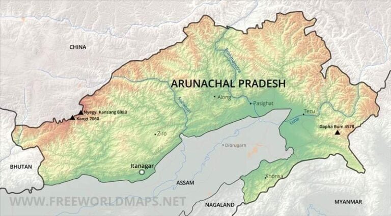
Physical Map of Arunachal Pradesh:-
Physical Map Of Arunachal Pradesh (Source:- freeworldmaps.net)
Geography Of Arunachal Pradesh:-
Arunachal Pradesh Located in Eastern Part of India. Arunachal Pradesh Shares it’s borders with the country like China, Bhutan, Myanmar and with the state of Assam and Nagaland.
Mountains and Relief:-
Relief range varies between plains that are a few hundred meters in height and mountains above 7,000 metres (23,000 ft). The elevation of the towns of Naharlagun, Pasighat and Tezu in the south are 290 m, 155 m and 210 m respectively, while Kangto, Nyegi Kangsang and the Gorichen group of mountains are some of the highest peaks in this region of the Himalayas. The southern borders of Arunachal Pradesh are encompassed by the Shivalik ranges which merge into plains. The hills and mountains have associated features such as valleys and intermontane plateaus, that is plateaus between mountains.
Parts of the Lohit district, Changlang district and Tirap district are covered by the Patkai hills. The hills extend towards Nagaland, and form a natural boundary between India and Burma.
Namcha Barwa Himal range extends into India up to Siyom River.
Major hills found in this region include:
Aka Hills
Daphla Hills
Miri Hills
Abor Hills
Mishmi Hills
Patkai Hills
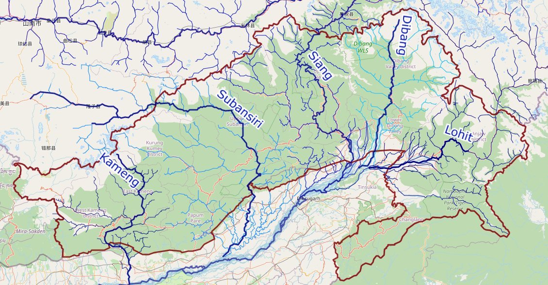
Rivers In Arunachal Pradesh:-
Arunachal Pradesh Rivers Basin
Water/wetland cover is 154,609 hectares (1,546.09 km2) or 1.91% of the total area. Out of this, 86% of wetlands are rivers. Lohit district and Dibang Valley district have the highest number of wetlands in the state.
The major river systems are (from west to east clockwise):
Kameng
Subansiri
Siang
Dibang
Lohit
All of these are fed by snow from the Himalayas and numerous rivers and rivulets and eventually flow into Siang/Brahmaputra. Abrasion by the rivers which flow through the mountains has created a broad valley, which is a major feature of the geography of the state.
Other rivers include Tawang Chu, Dikrong, Ranga, Kamala/Kamla, Kamplang, Siyum, Dihing/ Noadihing and Tirap.


Thanks for the little details… it helps me in project