
GUJARAT
CAPITAL:- GANDHINAGAR

About Gujarat:-
Gujarat also locally known as the “Jewel Of The West” and has the greenest Capital in Whole Asia “Gandhinagar”. Gujarat was formed on 1 May, 1960, by separating Bombay State by “Linguistic Line.” Now, It has the 33 Districts. Gujarat has the Total Population of 6,03,83,628 with the urban population of 2,57,23,426 and the Rural Population of 3,46,60,202. It has the Male Population of 3,14,82,282 and Female Population of 2,89,01,346 with Sex Ratio of 918 Females Per 1000 Males. Gujarat has the Density of 308 per Sq. km and the Literacy Rate of 79.31% (DATA ACCORDING TO CENSUS 2011) .
Geography Of Gujarat:-
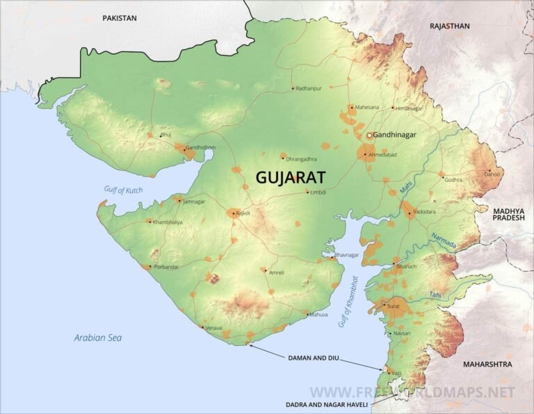
Gujarat is a state which is present in Eastern Zone of India. Gujarat has the Largest Coastline in Whole of India which is 1214 km in length covering 16 Coastal Districts. Gujarat is also the fifth largest state in India, with total area of 1,96,024 Sq. km. It shares it borders with Rajasthan, Madhya Pradesh, Maharashtra, Daman And Diu and Also with the Sindh Province of Pakistan. Gujarat also has the “Rann of Kutch” and it’s Area is about 7500 Sq. km and reputed as one of the largest Salt Desert in the World.
LIST OF SOME MAJORS RIVERS IN GUJARAT:-
- Narmada River
- Sabarmati River
- Mahi River
Machchhu River
- Hiran River
- Rupen River
- Kim River
DISTRICTS OF GUJARAT (With Official Links):-
States:-
Union Territories:-
| Andaman and Nicobar Island | Dada Nagar Haveli & Daman & Diu | Jammu & Kashmir | Lakshadweep |
| Chandigarh | The Government of NCT of Delhi | Ladakh | Puducherry |