
KARNATAKA
CAPITAL:- BANGALORE

About Karnataka:-
Karnataka, the state where sew and supply of “National Flag” done and state known as “Land of Tigers” because of largest Tiger population in India. Karnataka was Formed on 1st November, 1956 by merging the Kannada speaking regions of South India. Karnataka is 9th Largest State in India in terms of Population with total population of 6,10,98,000. Karnataka has the Rural Population of 3,74,69,000 and Urban Population of 2,36,29,000 with the Density of 319 per Sq. km. The state has the Male Population of 3,09,66,657 and the Female Population of 3,01,28,640 with the Sex-Ratio of 973 Females per 1000 Males. It has total of 31 Districts with the Literacy Rate of 75.36% (DATA ACCORDING TO CENSUS 2011) .
Physical Map of Karnataka:-
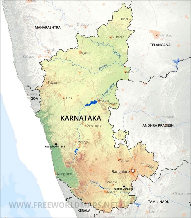
Geography Of Karnataka:-
Karnataka the “Largest Coffee Exporter” with the total export worth of 443 million Dollars and the “Land of Waterfalls” with 35 waterfalls and India’s Highest waterfall “Kunchikal Waterfalls” with the height of 455 metres (1,493ft.). It is the 6th Largest State in terms of area with the total area of 1,91,791 Sq. km. Karnataka Shares its borders with many state like Goa, Maharashtra, Telangana, Andhra Pradesh, Tamil Nadu and Kerala. The length of the coastline of Karnataka is 280 km,(Source). The highest point in Karnataka is the Mullayanagiri hill in Chikkamagaluru district which has an altitude of 1,929 metres (6,329 ft) above sea level.
The state is divisible in to three distinct geomorphic zones:
- The coastal plains, called the Karavali area lies between the Western Ghats and the Arabian Sea. The Karavali are lowlands, with moderate to high rainfall levels. This strip is around 320 km (200 mi) in length and 48–64 km (30–40 mi) wide.
- The Western Ghats, called Malenadu, is a mountain range running parallel to the Arabian Sea trending NNW-SSE, rising to about 900 m (3,000 ft) average height with some peaks over 1,000 m (3,300 ft) above sea level. The mountain rage is around 40 km (25 mi) wide and with moderate to high rainfall levels.
- The Deccan Plateau, called Bayalu Seeme, comprising the main inland region of the state, with an average elevation of 650 m (2,130 ft) above sea level. The plateau is relatively dry and verging on the semi-arid. The plateau is scattered with narrow ridges, and hills of schistose rock and granitic boulders.
Karnataka has one of the highest average elevations of Indian states, at 1,500 feet (460 m).
(Source:- https://en.wikipedia.org/wiki/Geography_of_Karnataka)
Some Major Rivers in India:-
- Krishna River
- Kaveri River
- Pennar River
- Netravati River
- Kalinadi River
- Manjra River
- Palar Sharavati River
- Bhima River
- Tung Abadra River
DISTRICTS (With Official Links):-
States:-
Union Territories:-
| Andaman and Nicobar Island | Dada Nagar Haveli & Daman & Diu | Jammu & Kashmir | Lakshadweep |
| Chandigarh | The Government of NCT of Delhi | Ladakh | Puducherry |