
MADHYA PRADESH
CAPITAL:- BHOPAL
About Madhya Pradesh:-
Madhya Pradesh, The state with Largest Tribal population in India with almost 21% and with the Largest Diamond reserve in India with total of 11 metric tonnes. Madhya Pradesh was formed on 1 November, 1956. Madhya Pradesh is the 6th largest state in India in terms of population with total population of 7,26,26,809 with the Density of 236 per Sq. km. The state has the Rural Population of 5,25,57,404 and the Urban Population of 2,00,69,405. It has the Male population of 3,76,12,306 and the Female population of 3,50,14,503 with the Sex-Ratio of 931 Females per 1000 Males. It has the total of 52 Districts with total of 10 divisions and the Literacy Rate of 69.32%. (DATA ACCORDING TO CENSUS 2011)
Physical Map of Madhya Pradesh:-
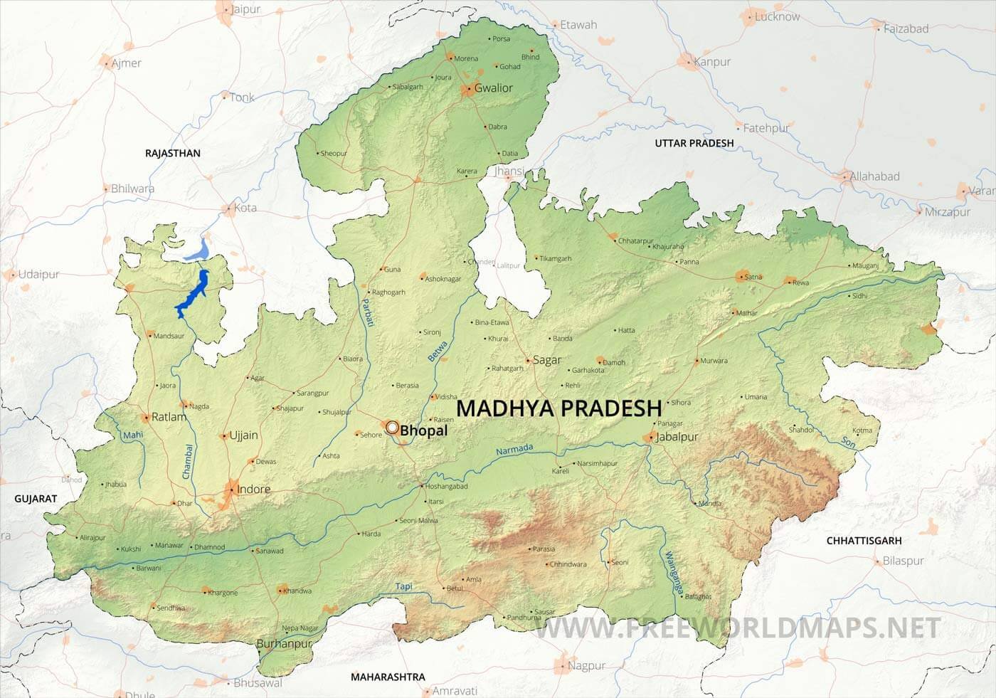
Geography of Madhya Pradesh:-
Madhya Pradesh, with the one of the oldest Cave collection “Touted” and oldest known Rock art in Indian Subcontinent “Bhimbetka site” is a Landlocked state located in the Center of India. Madhya Pradesh is second Largest state after Rajasthan with the total area of 3,08,245 Sq. km. The state shares its boundary with the states on the north by Uttar Pradesh, the east by Chhattisgarh, the south by Maharashtra and the west by Gujarat and Rajasthan. Madhya Pradesh lies over a transitional area between the Indo-Gangetic Plain in the north and the Deccan plateau in the south. It has the average elevation 90 metres to 1200 metres with the highest point of “The Dhupgarh Peak” with the height of 1,350 metres. Important ranges of hills are the Vindhya Range, in the west, and its northern branch, the Kaimur Hills, both of which reach elevations of 460 metres, and the Satpura, Mahadeo, and Maikala ranges, in the south, which have elevations of more than 900 metres. Northwest of the Vindhya Range is the Malwa Plateau ( 500 to 600 metres). Other features include the Rewa Plateau, in the rugged eastern region of the Vindhya Range, the Bundelkhand Upland, north of the Vindhyas, the Madhya Bharat Plateau, in the extreme northwest, and the Baghelkhand Plateau, in the northeast.
Drainage System of Madhya Pradesh
Drainage of Madhya Pradesh is divided into six major parts, such as
- Ganga Drainage System
- Narmada Drainage System
- Tapti Drainage System
- Godawari Drainage System
- Mahi Drainage System
- Mahanadi Drainage System
Some Major Rivers in Madhya Pradesh:-
- Narmada River
- Chambal River
- Tapti River
- Shipra River
- Sone River
- Mahanadi River
- Betwa River
- Indravati River
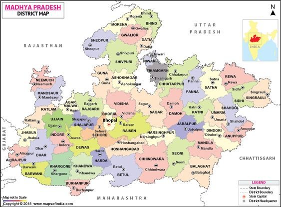
DISTRICTS OF MADHYA PRADESH (With Official Links):-
STATES:-
UNION TERITORRIES:-
| Andaman and Nicobar Island | Dada Nagar Haveli & Daman & Diu | Jammu & Kashmir | Lakshadweep |
| Chandigarh | The Government of NCT of Delhi | Ladakh | Puducherry |