
MAHARASHTRA
CAPITAL:- MUMBAI
About Maharashtra:-
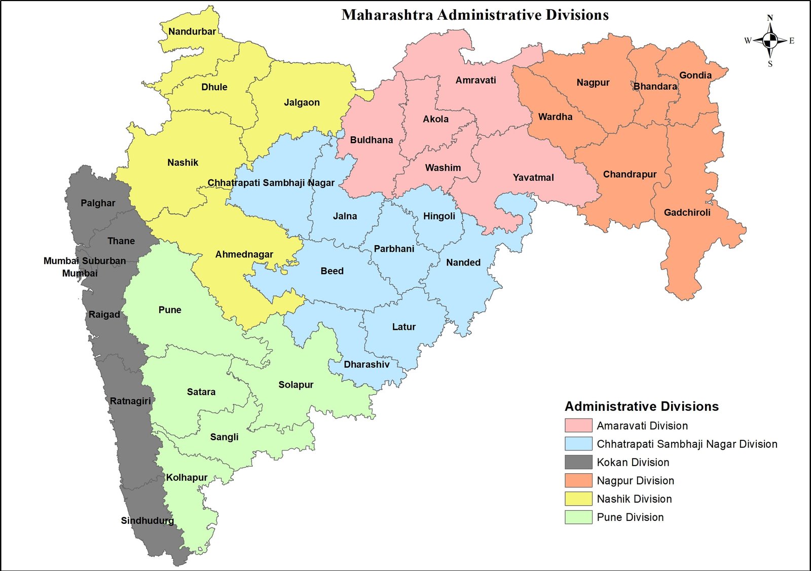
Maharashtra, where “Economic Capital of India” Mumbai and “Hollywood of India”, Maharashtra has the Highest GDP in India i.e., 473 billion. Maharashtra was separated in 1st May, 1960 due to linguistic differences with majority of Gujrati speaking people living in North. Maharashtra is the 2nd largest states in India in terms of Population with the total population of 11,23,74,333. The state has the Rural population of 6,15,58,660 and the Urban Population of 5,08,15,673 with the total Density of 365 per Sq. km. Maharashtra has the Male population of 5,82,43,056 and Female population of 5,41,31,277 with the Sex Ratio of 929 Females per 1000 Males. The state has the total of 6 Divisions and 36 Districts with the Literacy rate of 82.34%. (DATA ACCORDING TO CENSUS 2011)
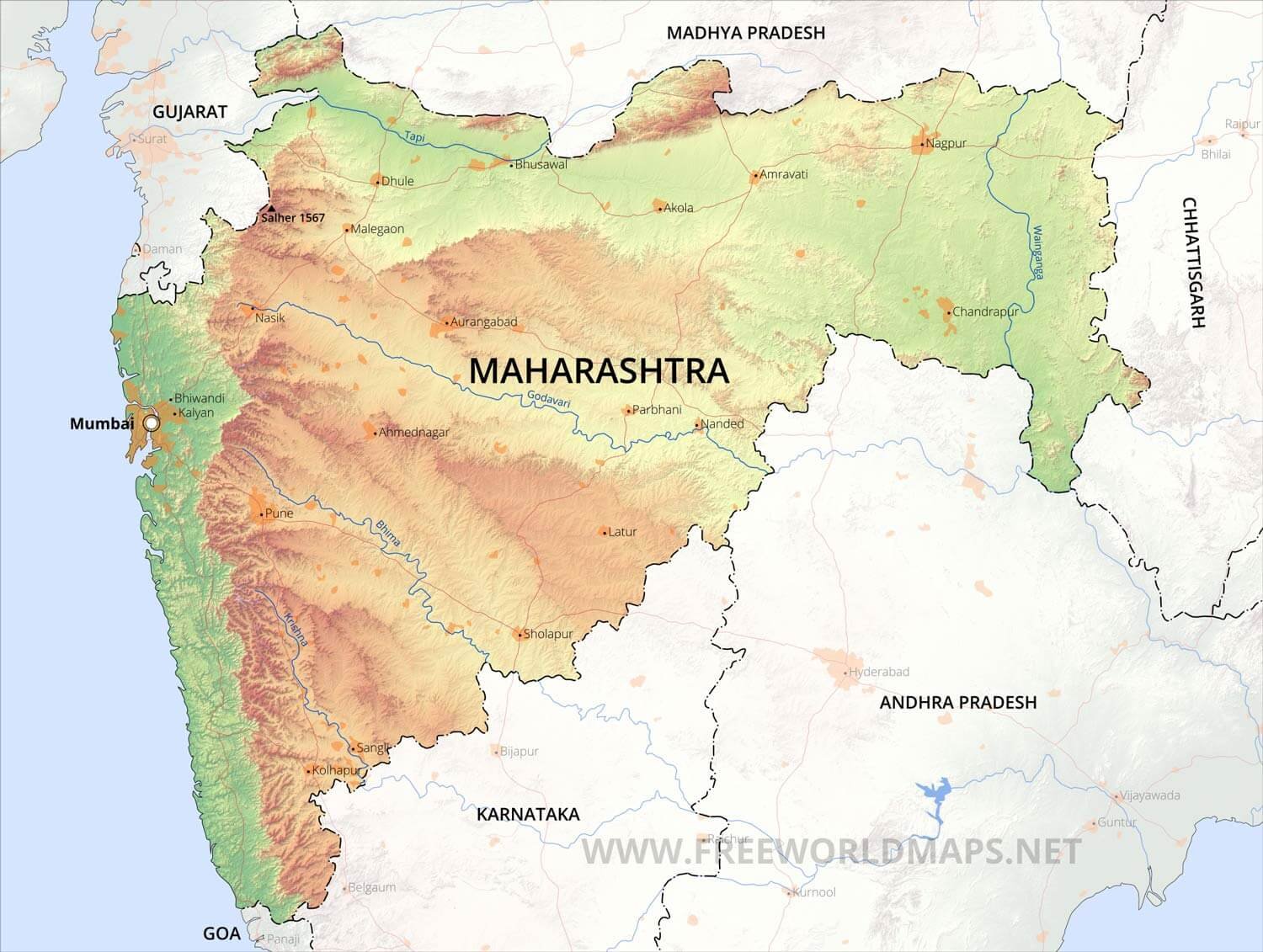
Physical Map of Maharashtra:-
Geography of Maharashtra:-
Maharashtra, A state located in West India with Tourism Capital of India “Chhatrapati Shambhaji Nagar”. Maharashtra is 3nd largest state in terms of Area with the total area of 3,07,713 Sq. km. The State of Maharashtra shares its border with the states of Madhya Pradesh to the north, Chhattisgarh to the east, Telangana to the southeast, Karnataka to the south and Goa to the southwest. The state of Gujarat lies to the northwest, with the Union territory of Dadra and Nagar Haveli sandwiched between the borders. Maharashtra has the coastline region is also known as the Konkan coast, which is 720 km long. The state shares its topology with Konkan Coast and Deccan Tableland.
Except around Mumbai, and along the eastern limits, the State of Maharashtra presents a monotonously uniform, flat-topped skyline. This topography of the state is the outcome of its geological structure. The state area, barring the extreme eastern Vidarbha region, parts of Kolhapur and Sindhudurg in the west, is practically co-terminus with the Deccan Traps.
The Sahyadri Range is the physical backbone of Maharashtra. Rising on an average to an elevation of 1000m. it falls in steep cliffs, to the Konkan on the west. Eastwards, the hill country falls in steps through a transitional area known as Maval to the plateau level. The series of crowning plateau on the crest forms a distinctive feature of the Sahyadri Range.
Some Major River In Maharashtra:-
- Bhima River
- Bindusara River
- Dahisar River
- Girna River
- Godavari River
- Indravati River
- Krishna River
- Kundalika River
- Mithi River or Mahim River
- Mutha River
- Oshiwara River
- Painganga River
- Patalganga River
- Pavna River
- Poisar River
- Purna River
- Savitri River
- Shastri River
- Tansa River
- Tapti River
- Thane Creek
- Vaan River
- Vaitarna River
- Vasai Creek
- Wainganga River
- Wardha River
(Source:- https://www.mumbaiorbit.in/rivers-in-maharashtra/index.html )
DISTRICTS OF MAHARSHTRA (With Official Links):-
STATES:-
UNION TERRITORIES:-
| Andaman and Nicobar Island | Dada Nagar Haveli & Daman & Diu | Jammu & Kashmir | Lakshadweep |
| Chandigarh | The Government of NCT of Delhi | Ladakh | Puducherry |