
RAJASTHAN
CAPITAL:-JAIPUR

About Rajasthan:-
Rajasthan, is also known as “The Land of Kings” and the Color Coded cities like, Jaipur “Pink City”, Jodhpur “Blue City”, Jhalawar “Purple City” etc. Rajasthan is also the place where one of the Earliest Ploughing Field in “Kalibangan” in the “Hanumangarh district”. Rajasthan was formed on 30 March, 1949 by merging “Rajputana Agency”in India, which has the total of 22 Princely states under British Rule. It is the 8th Largest State in terms of population with the total population of 6,85,48,437. The State has the Rural Population of 5,15,00,352 and the Urban Population of 1,70,48,085 with the population Density of 200 Per Sq. km. It has the Male Population of 3,55,50,997 and the Female Population of 3,29,97,440 with the Sex-Ratio of 928 Females per 1000 Males. It has the total of 33 Districts and the Literacy Rate of 66.11%. (DATA ACCORDING TO CENSUS 2011)
Physical Map of India:-
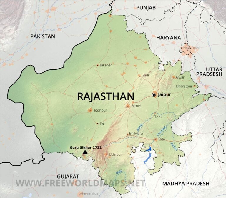
Geography of Rajasthan:-
Rajasthan, home to the India’s Oldest Mountain Range “Aravalli Range” with the length of ‘692 km’ with average elevation of “600 metres” and also has the India’s Largest Desert “Thar Desert” with the Area of about 2,00,000 Sq. km. The state also has the one of the most beautiful Jain Pilgrim site “Dilwara Temple” that was build in between of 11th century and 13th centuries AD by Vimal Shah and Tejpal, two brothers who were ministers in the court of Chalukya ruler Bhima I. Rajasthan is the largest state in India in terms of Land Area with the total Area of 3,42,239 Sq. km. It shares its border with many states like Gujarat, Madhya Pradesh, Uttar Pradesh, Haryana and Punjab and it also shares its border with the country of Pakistan.
Rajasthan has the average elevation of 225 metres (738ft) with the lowest point is the height of 100 metres (300ft) and the heighest peak is Guru Sikhar “Mount Abu” with the height of 1,722 metres (5,650ft). This region receives less than 400 mm of rain annually. Temperatures can sometimes exceed 45 °C in the summer months and drop below freezing point in the winter. The Godwar regions, Marwar regions, and Shekhawati regions lie in the thorn scrub forest zone, along with the city of Jodhpur.
Major Rivers in Rajasthan:-
- Banas River
- Ghaggar River
- Kali Singh River
- Kanthali River
- Luni River
- Parban River
- Sabi River
In all Rivers only Luni River is the ‘Saline River’ in whole India with the length of 495 km.
Districts of Rajasthan (Official Links):-
STATES:-
UNION TERRTORIES:-
| Andaman and Nicobar Island | Dada Nagar Haveli & Daman & Diu | Jammu & Kashmir | Lakshadweep |
| Chandigarh | The Government of NCT of Delhi | Ladakh | Puducherry |