
UTTAR PRADESH
CAPITAL:- LUCKNOW
About Uttar Pradesh:-
Uttar Pradesh, home to the one of the Seven Wonders of the World “Taj Mahal” and also has the one of the oldest cities in India “Varanasi”, which is believed to be 3000 years old. This state is also the birth place of many legends like Dhyan Chand (Allahabad), Lal Bahadur Shastri (Allahabad), Indra Gandhi (Rae Bareli) etc. The state also has the maximum number of seats in Parliament 80 in Lok Sabha and 31 in Rajya Sabha.
The state of Uttar Pradesh was established in 24 January, 1950 after renaming of “Union Province”. This state is largest state in India in terms of population and also the “World’s most populous state” with the total population of 19,98,12,341. The state has the Rural Population of 15,53,14,133 and Urban Population of 4,44,98,208 with the Density of 829 per Sq. km. It has the Male Population of 10,44,80,510 and Female Population of 9,53,31,831 with the Sex-Ratio of 912 Females per 1000 Males. The state has total of 75 Districts and the Literacy Rate of 67.68%. (DATA ACCORDING TO CENSUS 2011)
Physical Map of Uttar Pradesh:-
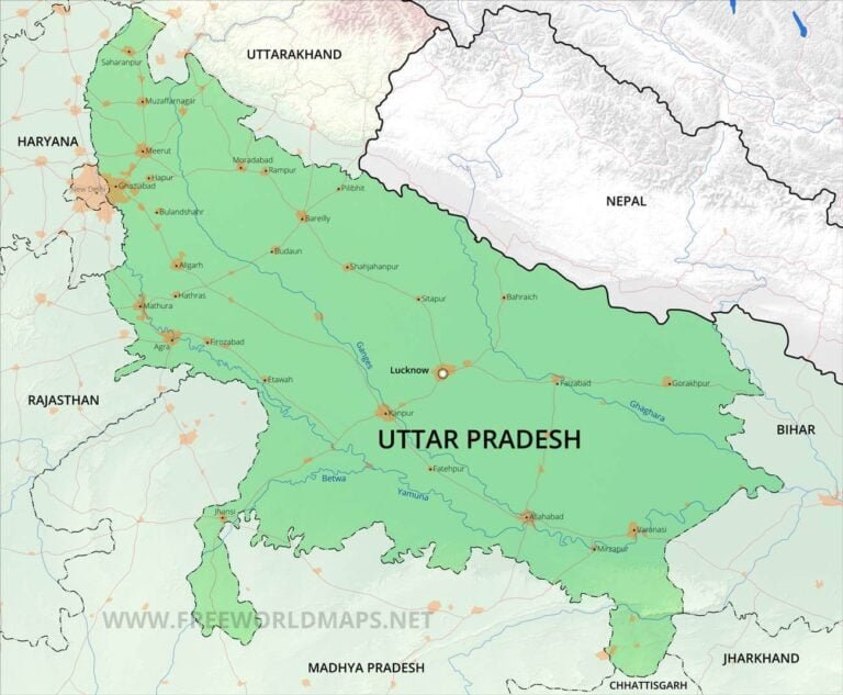
Geography of Uttar Pradesh:-
Uttar Pradesh, as it is most populated state in the world, it also hosts the World’s Largest Human Gathering in 2013 “Kumbh Mela”, over 12 crores people gathered in Allahabad and Uttar Pradesh is also home to the color changing tree, “Parijaat Tree” which is believe to be land from heaven by Lord Krishna. It is 4th largest state in India in terms of area with the total area of 2,43,286 Sq. km. The state shares its borders with seven states are, Uttarakhand, Haryana, Rajasthan, Madhya Pradesh, Chhattisgarh, Jharkhand, Bihar and it also shares its border with Delhi and the country of Nepal.
The state of Uttar Pradesh divided into four different physiographical regions:-
- The Shivalik Range, which is southern foothills of the Himalayas, slopes down into a boulder bed called Bhabar.
- Terai in the North
- The Gangetic Plain, which is so fertile and it play major role in states agriculture
- The Vindhya Hills in the south, with various topography like mountain, valley, plateau with limited water availability.
The state has the average elevation of 300 metres (1,000 ft), with lowest elevation in eastern side with 60 metres (200 ft) and the highest elevation at the peak of “Amsot Hills” with the height of 957 metres (3,140ft).
There are some major Rivers in Uttar Pradesh:-
- Betwa River
- Chambal River
- Ganga River
- Ghaghara River
- Yamuna River
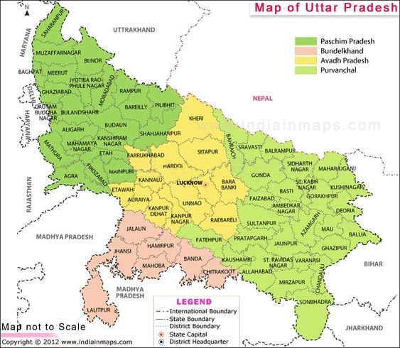
District of Uttar Pradesh (With Official Links):-
STATES:-
UNION TERRTORIES:-
| Andaman and Nicobar Island | Dada Nagar Haveli & Daman & Diu | Jammu & Kashmir | Lakshadweep |
| Chandigarh | The Government of NCT of Delhi | Ladakh | Puducherry |